Introduction
When a caller in Phoenix dials the same number as a caller in Boston, your system needs to decide — instantly — where to send each one. Geographic call routing handles this by reading a caller's location signal at the moment of call arrival and directing it to the correct regional office, queue, or agent, without manual intervention.
Most businesses set up geographic routing once and assume it runs itself. In practice, routing decisions depend on how location is detected, how rules are structured, and what happens when a match fails — and each layer has its own failure modes.
This guide explains how geographic call routing actually works — from the moment a call arrives to how the system decides where to send it — including the failure modes worth understanding before you deploy.
Key Takeaways
- Geographic call routing reads caller location signals at the moment of call arrival and matches them against predefined rules to forward the call to the right destination.
- Most commercial systems infer location from the caller's area code (NPA/NXX) — not their physical position.
- When no rule matches, a fallback configuration routes the call to a default destination instead of dropping it.
- Mobile callers frequently carry area codes from states they no longer live in, which can cause misrouting in area-code-based systems.
- Emergency systems (E911/NG911) use physical GPS and cell-tower data, not area codes like standard business routing does.
What Is Geographic Call Routing?
Geographic call routing is a call management method that uses a caller's location data — typically derived from area code, country code, or physical location signals — to automatically direct an inbound call to a specific destination: a regional office, contact center queue, or designated agent.
Without it, every call arriving at a shared business number lands in one general queue, regardless of where the caller is located. That forces manual transfers, stretches handle times, and reduces first-call resolution. The scale of that friction is real: 46% of customers are dissatisfied when transferred and 41% when placed on hold, according to SQM Group.
What Geographic Routing Is Not
Geographic routing is often confused with adjacent routing methods. The distinctions matter:
- Skills-based routing — matches callers to agents based on agent expertise or capability, not location
- Time-of-day routing — directs calls based on business hours, not geography
- Predictive routing — uses behavioral data and AI to anticipate caller needs
In practice, most call flows layer two or more of these methods — geographic routing narrows the destination first, then skills-based or time-of-day rules refine the match.
Types of Geographic Call Routing
| Type | How Location Is Determined | Common Use Case |
|---|---|---|
| Area code routing | NPA/NXX (area code + exchange prefix) from caller's registered number | Multi-location businesses, contact centers |
| Country code routing | International dialing prefix | Global operations, international support teams |
| Physical location routing | GPS data or cell tower triangulation | Mobile geo-routing, E911/NG911 emergency dispatch |
Area code routing is the most widely implemented form in commercial settings. Emergency services primarily use physical location routing, where precise real-time location is a legal requirement.
See how AI-powered geographic routing automates call distribution. Explore AI Call Automation
Comparing Geographic Routing Approaches
Not all geographic routing implementations work the same way. Here is how area code-based, GPS/physical location, and AI-powered approaches compare across the dimensions that matter most when choosing a solution:
| AI-Powered Geo Routing (EvaSpeaks) | GPS / Physical Location Routing | Area Code PSTN Routing | |
|---|---|---|---|
| Detection Method | IP + caller data + AI intent, dynamic rules | GPS coordinates, mobile location data | PSTN area code prefix matching |
| Best-fit Business Size | SMB to mid-market, multi-location | Mobile-first businesses | Large enterprise with PSTN infrastructure |
| Key Strengths | Easy to update routing rules, AI handles intent + geography | High location accuracy | Simple, widely supported |
| Implementation Complexity | Low - no code | Medium - API integration | Medium |
| Integration Capability | CRM, scheduling, EHR native | Custom API | Limited |
How Does Geographic Call Routing Work?
Geographic call routing follows a defined sequence: detect the caller's location, evaluate it against routing rules, forward the call to the matched destination. This happens in the time it takes for a call to connect.
Step 1: Call Arrival and Location Detection
When an inbound call reaches a business phone system (a PBX, VoIP platform, or cloud contact center), the system immediately reads the caller's telephone number metadata. It extracts the NPA (Numbering Plan Area, the first three digits) and NXX (Central Office code, the second three digits) as defined by NANPA — together forming the geographic identifier used to infer where the call originated.
One important qualification: area code routing identifies where a phone number was registered, not where the caller is physically located at the time of the call. Cisco's UCCE documentation describes this as using the Calling Line ID (CLID, sometimes called ANI) to map calls to area-code or local-exchange groupings.
For mobile callers, this distinction is significant. Pew Research found that approximately 10% of U.S. adults carried a cellphone number associated with a different state than where they lived, and an earlier Pew study found 39% county-level mismatch for mobile respondents. Area code routing will misread these callers' locations every time.
Step 2: Matching Against Routing Rules
Once the location signal is extracted, the system compares it against a routing rule database — a structured set of conditions that map geographic identifiers to specific destinations.
Rules are typically evaluated in priority order:
- The system checks the incoming NPA/NXX or country code against configured rules
- The first matching rule wins and the call is forwarded
- When multiple rules could match, the most specific rule (city-level rather than state-level, for example) takes precedence
This closest-match logic is documented across major platforms. Cisco CUCM uses a best-matching route pattern approach; Amazon Connect routes contacts based on agent routing profiles, queue hours, and flow logic defined in contact flows.
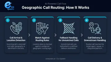
Step 3: Fallback Handling for Unmatched Calls
When a caller's location doesn't match any configured rule (due to an unrecognized area code, a number outside covered regions, or gaps in the routing database) the system needs a defined fallback path.
Without one, calls from unrecognized locations fail silently or deliver a poor experience. Amazon Connect's best practices documentation explicitly states that all error branches should route to a block that handles the error or terminates the contact cleanly.
That same principle applies to any well-configured platform. EvaSpeaks supports configurable call-flow routing rules and scripts, so administrators can define fallback destinations that catch calls when location data is ambiguous or unrecognized. Because EvaSpeaks manages routing logic through a non-technical admin dashboard, businesses can update geographic routing rules as they open new service areas or change staffing — without filing an IT ticket or modifying code.
Step 4: Call Delivery and Downstream Handling
Once delivered to the correct destination, the call can trigger additional routing layers:
- Skills-based routing — match to the best available agent
- Availability checks — queue if no agent is free
- Time-of-day rules — overflow to another location after hours
- CRM logging and analytics — capture routing outcome, call duration, and caller data
Geographic routing determines where a call lands. Everything that happens after — queuing, agent matching, logging — depends on getting that first decision right.
Watch geographic call routing in action on a real call. Watch AI Call Flow Demo
Where Geographic Call Routing Is Used
Multi-Location Businesses
Companies with regional offices use geographic routing to connect callers with the location closest to them. This reduces unnecessary transfers, keeps callers with agents who know local regulations or time zones, and shortens handle times. ICMI's 2025 contact center survey found that 85% of contact centers measure abandonment rate and 84% measure average handle time — both metrics that routing accuracy directly affects.
Large Contact Centers
In national or international contact centers, geographic routing distributes call volume across regional teams, preventing any single queue from becoming overloaded during peak periods. When combined with skills-based routing, it narrows the agent pool to those who are both geographically relevant and capability-matched.
Emergency Services (E911/NG911)
Emergency call routing is the most precise and heavily regulated form of geographic routing. Under Ray Baum's Act (FCC rules adopted August 1, 2019, effective January 6, 2020), carriers are required to convey dispatchable location with 911 calls.
This means a validated street address plus any additional detail — suite, floor, or apartment number — needed to pinpoint the caller. The framework breaks down into three tiers:
- E911 Phase I provides the PSAP with the caller's phone number and the cell site location
- E911 Phase II requires latitude and longitude coordinates meeting FCC accuracy standards
- NG911 uses GIS data and functions like the Emergency Call Routing Function (ECRF) and Location Validation Function (LVF) to route calls to the correct Public Safety Answering Point (PSAP)
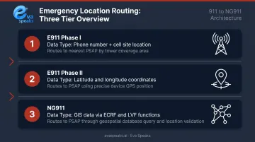
This level of location precision is a legal requirement for emergency services, and works quite differently from how most commercial routing systems operate.
See how businesses in your industry use location-based call routing. See Industry Use Cases
Common Challenges in Geographic Call Routing
Geographic routing works well when caller data is clean and routing rules are current — but several failure points can undermine it in production. Here's where teams run into trouble most often.
Mobile Caller Misrouting
Area code routing assumes the caller's number reflects their current location. For mobile callers, that assumption breaks regularly. A caller with a New York area code dialing in from California routes to the wrong regional team. Businesses with high mobile call volumes should look at GPS-based or IP-based location detection as a fallback, since area codes alone don't reflect where someone actually is.
Database Gaps
If a caller's area code isn't mapped in the routing rule database, the call drops to fallback rather than the intended destination. This happens when:
- New service areas are added without updating routing rules
- Number portability changes which carrier serves an area code
- International callers dial in from codes not included in the configuration
Regular audits of routing rules — especially after adding coverage areas — are the primary defense against this.
Layered Routing Conflicts
When geographic routing combines with time-of-day rules, skills-based routing, and IVR branches, conflicting conditions can produce unexpected behavior. Two rules that fire simultaneously will conflict and route incorrectly if priority order isn't explicitly defined.
Test routing logic end-to-end in a staging environment before deploying to production. Amazon Connect's documentation recommends validating all error branches as part of flow design — a discipline worth applying regardless of which platform you're on.
Have questions about geographic routing for your business? Talk to an AI Communication Expert
Frequently Asked Questions
What is geographic call routing?
Geographic call routing is an automated process that directs inbound calls to specific destinations based on the caller's location, typically identified by area code or country code. It reduces unnecessary transfers and hold times by connecting callers to the most regionally appropriate team or office as soon as the call connects.
How does geographic call routing work?
The phone system reads the caller's number metadata (NPA/NXX area code or country code) at the moment of call arrival, matches it against predefined routing rules, and forwards the call to the designated destination. When no rule matches, a fallback configuration routes the call to a default destination instead of dropping it.
How are phone calls routed?
Call routing works by evaluating an incoming call against a set of rules — based on number dialed, caller location, time of day, agent availability, or other criteria — and directing the call to the appropriate destination: an agent, queue, voicemail, or IVR branch. Rules are evaluated in priority order, with the most specific match winning.
What is location-based routing and how is it used for 911?
Location-based routing uses a caller's physical location — via GPS or cell tower data — rather than their registered area code for routing decisions. In 911 systems, this ensures emergency calls reach the correct PSAP for the caller's actual location, which is a legal requirement under Ray Baum's Act and FCC dispatchable location rules.
What is geo-based DNS routing?
Geo-based DNS routing is a web infrastructure concept that directs internet traffic to the nearest or most optimal server based on a user's IP-derived location. It's distinct from telephone geographic call routing, though both use location signals to optimize where traffic is directed. AWS Route 53 and Cloudflare both offer geolocation DNS routing for web applications.
What happens when a caller's location can't be identified?
When a caller's location doesn't match any configured routing rule — due to an unrecognized area code or missing location data — the system applies a fallback rule to route the call to a default destination such as a general queue or main office. Without a configured fallback, the call may drop or fail to connect the caller.
Conclusion
Geographic call routing works by extracting a location signal from an inbound call, matching it against a defined rule set, and delivering the call to the appropriate destination — with fallback rules ensuring no call goes unhandled when a match fails.
How location gets detected, where rule evaluation breaks down, and how fallbacks are structured — these details separate a routing system that works from one that silently misroutes calls. For businesses handling inbound volume across multiple locations, that gap shows up in transfer rates, hold times, and whether callers reach the right person on the first try.
If your current setup isn't delivering on those metrics, the location detection layer is usually the first place to investigate.